Together we stand
From a global pandemic to forest fires, we’ve lived through it all in one year. If 2020 taught us anything, it’s that our strength is reflected in our preparedness to face the unknown – whether it’s emergency care or a natural disaster. Putting technology to good, our teams built the solutions that help the healthcare and emergency response teams in real-time during our EMEA Hackathon.
Fast Aid
Bringing communities together
Challenge
The average response time between the call and Emergency Services arriving on the scene can sometimes be a matter of life or death. COVID-19 has over-stretched the NHS, including ambulance response times. Category 1 emergencies benefit from a 7-8 minute response time, but Categories 2-4 (which includes heart attack, stroke, sepsis, and major burns) have response times greater than 30 minutes. The UK has approximately 2.3 million trained First Aiders and Mental First Aiders who could bridge the gap between call and response for the NHS Emergency Teams. In 2018 the Red Cross identified that only one in twenty adults in the UK had sufficient knowledge to be able to provide aid in an emergency situation.
Solution
Fast Aid is a lightweight app that works on minimal data/bandwidths without data roaming to get a first aider to an incident fast – helping save lives. Fast Aid leverages experience within the community to provide resources on the ground to help deal with category 2-4 emergencies until the Emergency Services can arrive. Fast Aid also combines the government leadership with corporate and private Sector partners to extend first-aid training and knowledge within the UK to further support the NHS, enhancing the reach within a wide network of qualified First Aiders, enabling a quicker response to incidents and alleviating pressure on NHS services.
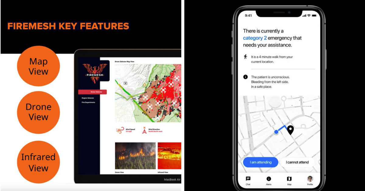
FireMesh
Streamlining emergency services to save lives
Challenge
With Global Warming on the rise, bushfires have become a real-world problem for the residents, communities, and wildlife – as evidenced throughout the state of California and across Australia’s Gold Coast. Fire Brigades need a sophisticated solution to obtain, analyze, and utilize new data sources to drive real-time Central Command decisions, track fire progression, travel direction, and its ferocity for Front Line Response teams - to drive predictive outcomes and save lives.
The 2019 bushfires exposed the frailties of leaning on old methods; text, radio, and TV. To date, there are several advanced standalone technologies, including satellite, drones, robotics, VR, and IoT. However, integrating these technologies with the firefighter response and using this data to provide real-time insights and inform residents is difficult.
Solution
FireMesh is a sophisticated neural network of device streams that predicts, augments, informs, and ultimately saves lives! The network connects a central command to front-line fighters and residents.
FireMesh will help coordinate effective execution across the country, region, and state boards through our real-time eye-in-the-sky technology. Streams from drones equipped with infrared, heat, and other scanners feed data into our unique ingestion engine, processing terabytes of data, analyzing with AI, and real-time predictions related to our unique applications. We empower Firefighters on the ground with sophisticated visual insights, combined with a real-time geographical view for a holistic view of the landscape to drive coordinated results to strategically tackle bush fires. Satellites, including weather and mapping, will be used to augment real-time information on the movement of fires, people, and paths of danger.
On the ground, body cam streams with sophisticated sensors fitted to the fire colleagues feed data into our engine, and mobile devices provide geotagging, positioning, and warnings. Today’s residents rely on outdated early warning text systems, local radio, and TV. FireMesh goes further to save lives with a complimentary mobile application to provide residents with real-time insights on bush fire danger zones, travel direction, heat levels, smoke levels, ferocity indications, and suggested escape routes.
Preparedness is the need of the hour. Would you like our teams to reimagine and bring to life your ideas for better global preparedness? Get in touch.
Share this Blog with colleagues